


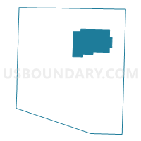
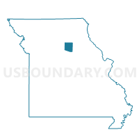
Cairo Voting District, Randolph County, Missouri
About
Outline

Summary
| Unique Area Identifier | 609512 |
| Name | Cairo Voting District |
| County | Randolph County |
| State | Missouri |
| Area (square miles) | 35.91 |
| Land Area (square miles) | 35.37 |
| Water Area (square miles) | 0.54 |
| % of Land Area | 98.50 |
| % of Water Area | 1.50 |
| Latitude of the Internal Point | 39.50760440 |
| Longtitude of the Internal Point | -92.42786820 |
Maps

Graphs
Select a template below for downloading or customizing gragh for Cairo Voting District, Randolph County, Missouri


Neighbors
Neighoring Voting District (by Name) Neighboring Voting District on the Map
- Huntsville Voting District, Randolph County, MO
- Jacksonville Voting District, Randolph County, MO
- Levicks Mill Voting District, Randolph County, MO
- North Sugar Creek Voting District, Randolph County, MO
- Union Voting District, Randolph County, MO
Top 10 Neighboring County Subdivision (by Population) Neighboring County Subdivision on the Map
- North Sugar Creek township, Randolph County, MO (5,994)
- Salt Springs township, Randolph County, MO (2,873)
- Cairo township, Randolph County, MO (1,257)
- Union township, Randolph County, MO (957)
- Jackson township, Randolph County, MO (411)
- Salt River township, Randolph County, MO (383)
Top 10 Neighboring Place (by Population) Neighboring Place on the Map
Top 10 Neighboring Unified School District (by Population) Neighboring Unified School District on the Map
- Moberly School District, MO (16,390)
- Westran R-I School District, MO (3,668)
- Northeast Randolph County R-IV School District, MO (2,015)